NVIDIA Partner · 6.2M+ Farmers · 50+ Countries
NVIDIA Inception Partner
ISRO Authorised
The Enterprise
Agricultural Intelligence
Platform
MapMyCrop transforms agricultural data into actionable decisions. AI-powered crop monitoring, precision analytics, and enterprise-grade APIs trusted by banks, insurers, and governments worldwide.
6.2M+
Farmers Served
50+
Countries
98%
Accuracy Rate
500+
Enterprise Clients
CropSense AI Dashboard — Live View
🛰 Satellite feed · Live · India, Africa, SE Asia
94.2%
Crop Health Index
0.72
NDVI Score
+18%
Yield Forecast
2.4M ha
Fields Monitored Today
Real-time AI
Powered by NVIDIA
Product Suite
One Platform. Every Agricultural Need.
From field-level crop intelligence to national-scale analytics — MapMyCrop’s modular platform scales from SME agribusinesses to sovereign governments.
Flagship Product
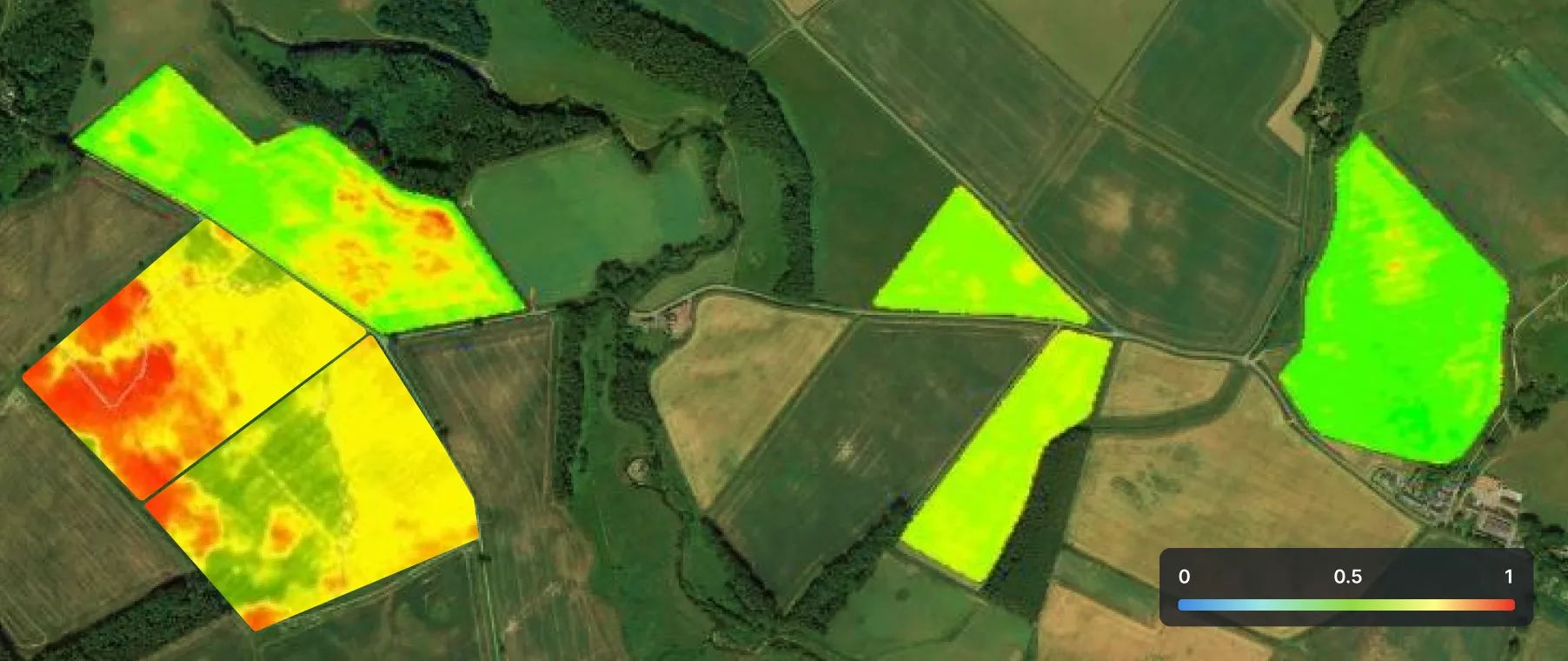
CropSense AI
Our most advanced satellite-powered crop monitoring system. Real-time NDVI analysis, crop health scoring, pest prediction, and yield forecasting using multi-spectral imagery processed by NVIDIA-accelerated AI models.
- 10m resolution satellite imagery
- Daily crop health updates
- AI yield forecast (±5% accuracy)
- Pest & disease early warning
- 100+ crop varieties supported
- REST API + dashboard access
Farm Management
FarmOS Enterprise
Complete digital farm management — from land records to harvest logs. Multi-farm, multi-crop, multi-user with offline mobile support.
- Land parcel management
- Input tracking & cost analysis
- Offline-first mobile app
Water Intelligence
AquaTrack Pro
AI-driven irrigation scheduling using soil moisture, ET rates, weather forecasts, and crop water requirements.
- 30% water savings on average
- IoT sensor integration
- Automated drip scheduling
Soil Intelligence
SoilIQ
AI soil health platform combining lab data, remote sensing, and historical records into actionable fertility recommendations.
- N-P-K recommendation engine
- Carbon sequestration tracking
- Soil health scoring (1–100)
Developer Platform
AgriInsight API
Enterprise REST APIs for embedding agricultural intelligence into banking, insurance, ERP, and government systems.
- 99.9% SLA uptime
- 200+ endpoints
- Sandbox + production tiers
Industries
Built for Every Sector That Depends on Agriculture
From rural banks assessing crop loans to national governments mapping food security — MapMyCrop serves the full agricultural value chain.
Transform Crop Loan Underwriting with AI
Replace manual field visits with satellite-verified crop data. MapMyCrop provides banks and NBFCs with real-time farm verification, yield-based credit scoring, and continuous loan monitoring — reducing NPA risk by up to 40%.
40%
Reduction in NPAs
3x
Faster Loan Processing
₹2,400 Cr
Loans Underwritten
50+
Banking Partners
🏦
Loan Risk Dashboard
AgriCredit Module · Live Data
✅ AI Risk Score: Low-Risk Portfolio — 94% repayment probability
Automate Crop Loss Assessment at Scale
MapMyCrop's parametric insurance module delivers satellite-verified crop damage assessments within 48 hours of a weather event — eliminating ground surveys and reducing claims processing costs by 60%.
48 hrs
Claims Assessment
60%
Lower Claim Cost
4M+
Policies Supported
98.2%
Assessment Accuracy
🛡️
Claims Intelligence Module
Auto-assessment · Satellite verified
⚡Cyclone Damage Alert: 12,400 ha affected · Auto-claim triggered
National Agriculture Monitoring at Scale
Governments and policy bodies use MapMyCrop to monitor national crop patterns, track food security metrics, allocate subsidies, and plan disaster relief — covering millions of farms from a single command dashboard.
15+
State Govts Deployed
220M ha
Monitored
Real-time
Food Security Index
ISO 27001
Data Security
🏛️
National Crop Dashboard
Command center · 220M ha coverage
📊National food production forecast: +6.3% vs last Kharif season
Supply Chain Intelligence for Agri Enterprises
Agri corporates, FPOs, and commodity traders use MapMyCrop to forecast procurement volumes, optimize sourcing routes, and ensure traceability from farm to warehouse.
25%
Lower Procurement Cost
Real-time
Harvest Forecasting
End-to-end
Farm Traceability
200+
Enterprise Partners
🚜
Procurement Intelligence
Supply chain · Harvest forecast
🚛Procurement forecast: 48,000 MT available in 30 days
Farm-to-Fork Transparency for Food Brands
Food companies and retailers use MapMyCrop to verify sustainable sourcing, track residue compliance, and build consumer trust through blockchain-anchored farm-level traceability.
100%
Farm Traceability
ESG
Compliant Reporting
Zero
Residue Alerts
QR
Consumer Scan Ready
🥬
Traceability Dashboard
Farm-to-fork · Blockchain verified
✅Organic certified · No residues detected · QR scan ready
AI Capabilities
Intelligence That Drives Real Outcomes
Powered by NVIDIA accelerated computing and trained on 8 years of multi-source agricultural data across 100+ crop varieties.
🛰️
Multi-Spectral Satellite Analysis
Process Sentinel-2, Landsat, and RISAT imagery daily. NDVI, NDWI, LAI, and 40+ vegetation indices computed automatically at field level.
10m
Resolution · Daily refresh
🌾
Yield Prediction Engine
LSTM + Transformer models trained on 8 years of yield data, weather patterns, and satellite observations predict harvest 60 days in advance.
±5%
Forecast accuracy · 60-day lead
🐛
Pest & Disease Detection
Computer vision models identify 200+ crop diseases and pests from drone or smartphone images with early warning 2–3 weeks before visual onset.
94%
Detection accuracy · 200+ threats
🌦️
Hyperlocal Weather Intelligence
Proprietary downscaling of global weather models to 1km grid resolution. 14-day forecasts with crop-specific risk alerts for frost, drought, and excess rainfall.
1 km
Grid resolution · 14-day outlook
💧
Precision Irrigation AI
Evapotranspiration-based irrigation scheduling combining soil sensors, weather data, and crop growth stage models to reduce water use by 30%.
30%
Water savings · IoT-enabled
📋
Automated Compliance Reporting
Generate satellite-verified crop reports for ESG disclosures, government subsidies, bank audits, and insurance claims — fully automated, audit-ready.
100%
Automated · Audit-ready reports